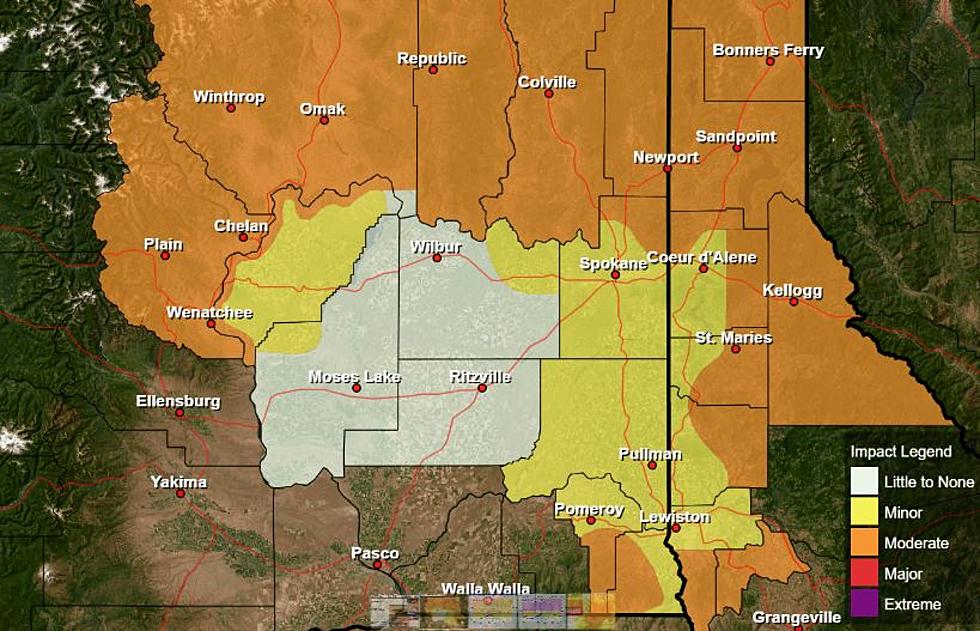
Lohmann: Heat Wave Will Be Short Lived
For those waiting for hot, dog-days of summer weather, this is your week, but enjoy it while you can. Marilyn Lohmann, meteorologist with the National Weather Service said while Wednesday is expected to be another hot one with highs in the triple digits, it should also be the peak.
“By Thursday and Friday, we’ll see about a five degree temperature drop in high temperatures each day. And then when we hit the weekend, we’ll be looking at highs right round 80 degrees. Just a very brief hot spell, as compared to sometimes how we see it drag on for days or even a week.”
Lohmann said starting this weekend, we’ll see a more active weather pattern, with two systems pointed at the northwest. The first is expected to move into our area Friday.
“That will bring showers and thunderstorms to much of the Inland Northwest, we’ll probably see some rain amounts from 0.1” to 0.25”, with maybe a few locations up to 0.50”, as we kind of see some monsoon moisture and a low pressure move across the region.”
Lohmann said we’ll dry out a bit and rebound temperature wise early next week, but that next system is expected to move in just before next weekend. As we look toward the rest of August, Lohmann says we can expect near to below normal temperatures and normal to slightly above normal precipitation.
If you have a story idea for the Washington Ag Network, call (509) 547-1618, or e-mail gvaagen@cherrycreekradio.com
More From PNW Ag Network