Washington Snowpack Rebounded Nicely In January
After an incredibly slow start to the snow season, things have improved in the Washington mountains. Scott Pattee with NRCS said the statewide snowpack is now 93% of average, a welcomed increase from the 57% of average reported this time last month. Pattee said January was exactly what the area needed.
“I think I was quoting somewhere around 130% of normal snowfall for the rest of the season, to get close to normal. We well exceeded that during the month of January, to get up where we are today. That’s for darn sure.”
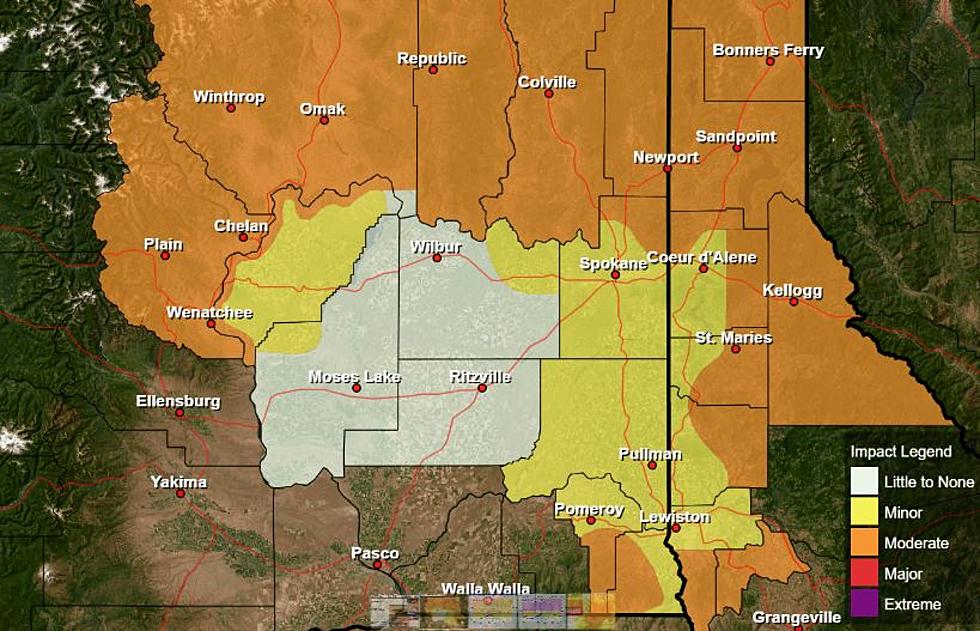
As far as the local snow basins are concerned:
- The Upper Columbia is 105% of average
- The Spokane is 102% of average
- The Central Columbia/Wenatchee is 92% of average
- The Upper Yakima is 80% of average
- The Lower Yakima is 101% of average
- The Walla Walla is 114% of average
- The Lower Snake is 101% of average
While that’s all very good news, Pattee said there are a few reasons for concern. He said the snow level is very high right now, with rain showers being reported on passes across Washington. And right now, there’s nothing encouraging when it comes to the weather forecast.
“The National Weather Service’s latest forecast, put us at equal chances, which means an equal chance of above, below or near normal, for both temperature and precipitation. So, it’s really anybody’s guess at this point, and it’s going to be a wait and see game.”
Pattee added February and even March can be very snowy months for Washington, but again the temperatures and snow level will play a key role in the weeks ahead.
If you have a story idea for the Washington Ag Network, call (509) 547-1618, or e-mail gvaagen@cherrycreekradio.com
More From PNW Ag Network