Showers Expected To Move In As Spring Officially Starts
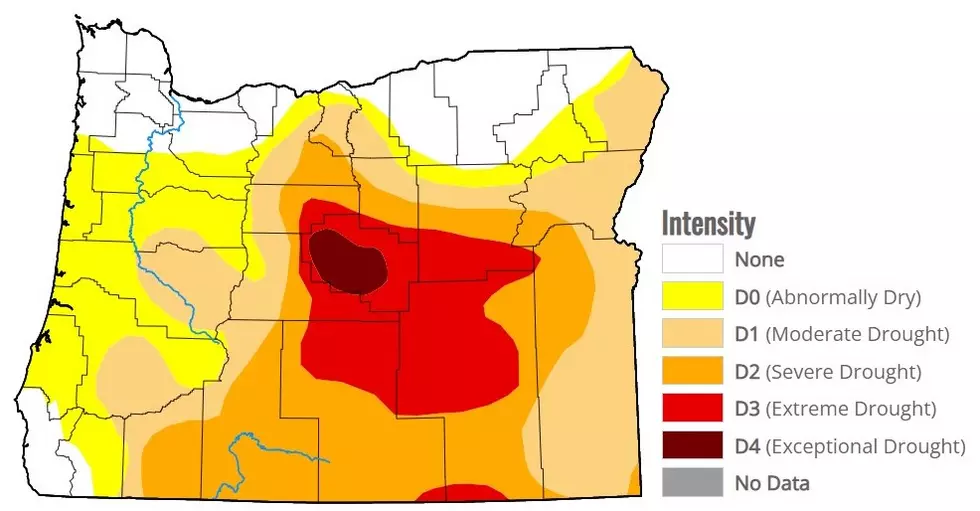
Spring start on Thursday; at 8:50 a.m. Pacific to be specific. But winter did not leave without making it’s departure known. Marilyn Lohmann, meteorologist with the National Weather Servcie says a strong low pressure styemt dove into the Northwest last week, ushering in unseasonably cold temperatures. Lohmann says those temperatures were cold enough to impact are soil readings.
“We’re currently seeing soil temperatures in the mid and upper 30’s, a few of them just above 40. Hopefully those will kind of change as we head through this week. And we moderate back to more normal temperature readings. Hopefully we’ll start to see more of those readings in the 40’s and maybe even 50’s as we creep through the next week.”
Unfortunately, last week’s low did not bring a lot of needed precipitation to the area. However, that could change as we look to the coming days. Lohmann said Washington, Oregon and Idaho should expect cooler than normal temperatures through the end of the month.
“But we are expecting maybe normal to above normal precipitation. So, I think after we get this system early next week, we start we’ll start to see a couple more systems after that that will kind of start those spring rains, but in turn we’ll still be a little on the cold side. I don’t think it will be until April until we’ll start to see a change into some warmer temperatures at this point.”
Lohmann added the last time the entire Northwest saw a healthy dose of rain; mid-February.
If you have a story idea for the Washington Ag Network, call (509) 547-1618, or e-mail gvaagen@cherrycreekradio.com
More From PNW Ag Network