Early August Expected To Remain Dry, Maybe Not So Hot

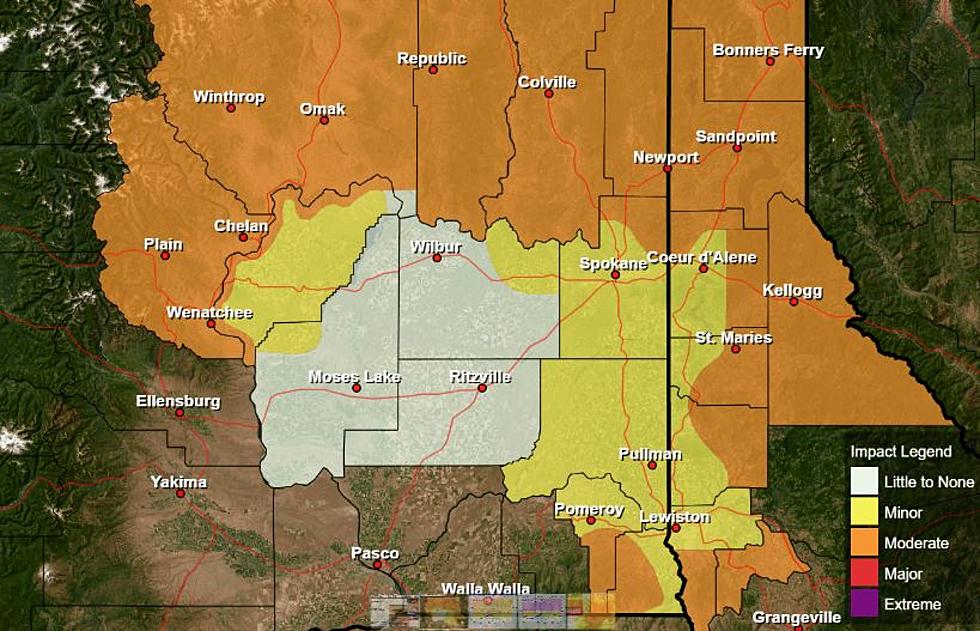
With temperatures expected in the triple digits Wednesday and Thursday, it’s safe to say the Inland Northwest is in the middle of a heat wave. Will this hot weather, with daytime highs 10, 15 even 20 degrees above normal, continue as we move into the month of August?
Don’t count on it, says meteorologist Marilyn Lohmann. She says it looks like temperatures will cool down as we head into the weekend, and temperatures will remain around average heading into next week.
“We’re losing daylight a lot quicker, we’ve already lost about 20 minutes, this month already and we’ll see sunrise not occurring before five o’clock by the end of the month. And we’ll start to see some better recoveries during the nighttime hours with that humidity as well. Hopefully we’ll continue to have more successful harvests with those kinds of conditions.”
Lohmann said right now, she expects the dry pattern to continue into the first week of August. But, she was quick to note that August is a month of change, and with all of the monsoon activity taking place in the American southwest, we could see thunder storms and rain showers as August marches on.
She added some models even call for early “fall like” weather as we close out August.
If you have a story idea for the Washington Ag Network, call (509) 547-1618, or e-mail gvaagen@cherrycreekmedia.com
More From PNW Ag Network