Despite Solid Statewide Numbers, Southern Oregon Snowpack Is MIA
The statewide snowpack for Oregon looks pretty good for this time of year, at 112% of average. However, things are not well across the entire state. Scott Oviatt, with NRCS-Oregon, said if you were to draw a line between Eugene and Ontario, snow packs look really good on the northern side, thanks to cooler temperatures an additional storm activity since mid-February.
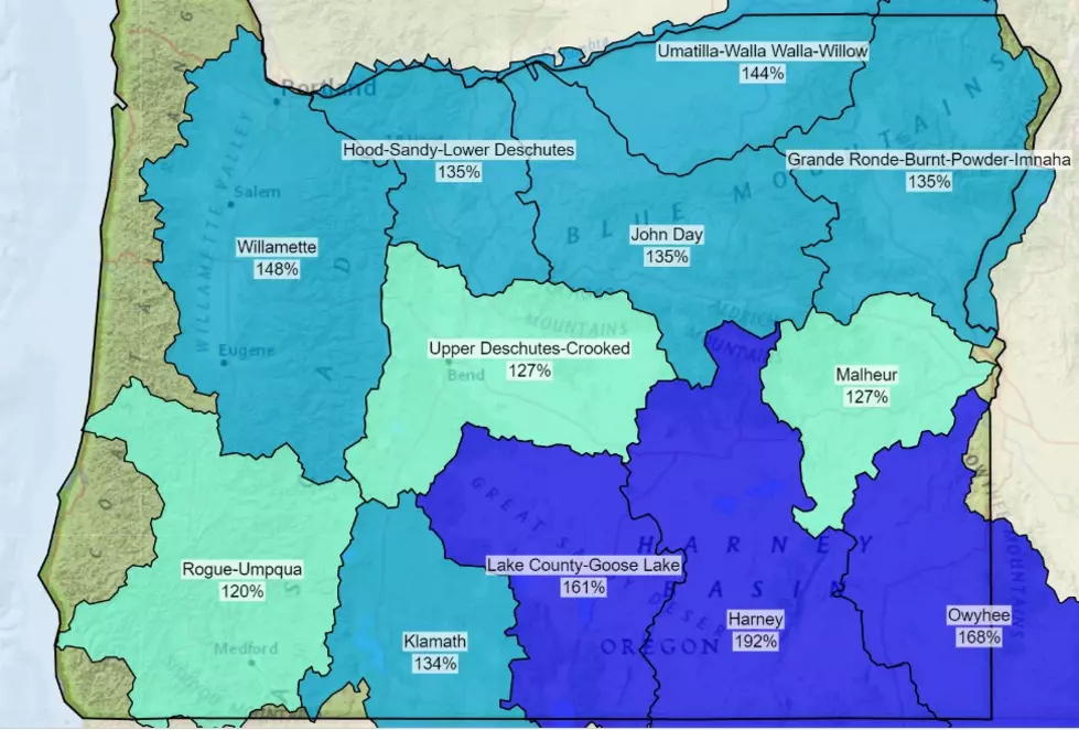
“So, many parts of the state in particular, the Umatilla-Walla Walla-Willow Basin, and the Hood-Sandy-Lower Deschutes Basin, are well above normal. But when we look at the Klamath and Lake County-Goose Lake region, we’re well below normal, and that also includes the Owyhee Basin, so it’s a take of two stories at this point.”
Here are the latest snowpack numbers at basins across Oregon:
- Grande Ronde-Burnt-Powder-Imnaha is 123% of average
- Umatilla-Walla Walla-Willow is 134% of average
- Hood-Sandy-Lower Deschutes 138% of average
- Willamette is 118% of average
- John Day is 103% of average
- Upper Deschutes-Crooked is 100% of average
- Harney is 92% of average
- Malheur is 71% of average
- Owyhee is 68% of average
- Lake County-Goose Lake 65% of average
- Klamath 75% of average
- Rouge-Umpqua is 82% of average
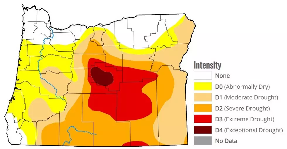
Oviatt added many of the lower elevations across southern Oregon are very dry as well, with some locations already reporting Extreme or Exceptional droughts. And he noted this pattern has been going on for years.
“If we go back to the beginning of, October 1st, 2019, and look at many of our sites in southwestern Oregon, these are all-time record lows in terms of precipitation and in terms of snowpack.”
If you have a story idea for the PNW Ag Network, call (509) 547-1618, or e-mail gvaagen@cherrycreekmedia.com
More From PNW Ag Network