Hot Temperatures Expected As Summer Starts This Weekend
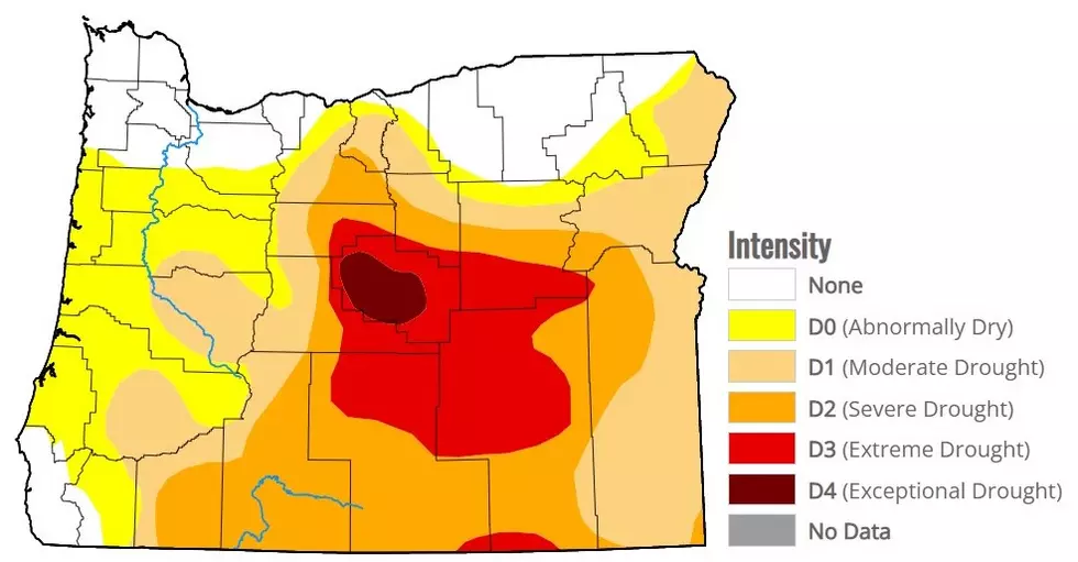
After months of very dry, in some cases record dry conditions, spring looks to go out on an active and wet note. The Northwest has seen a dramatic increase in showers and thunderstorms over the past two weeks.
Marilyn Lohmann, meteorologist for the National Weather Service said this weather is more similar to what we should have seen in the month of May. And when it comes to those showers and thunderstorms, she said they are not helping to address the ongoing drought, since the storms are so hit and miss, and precipitation totals are that great.
“I think the benefit with these showers and thunderstorms come in that we’ve had a period of cooler temperatures as well, so that kind of helps plant recovery and those cooler temperatures kind of help us prolong what moisture we do have.”
Lohmann said as we approach the weekend, the low system off the coast of Washington providing these storms should move on, revealing a return to sunny and dry weather, which mean hot weather.
“You know, we’ll start summer with some much warmer temperatures, maybe a little bit of a break in between, and then by the end of the month, the models are showing a return to some very hot conditions by the end of the month.”
Lohmann added temperatures as we approach the end of June could climb anywhere between 15 and 20 degrees above average.
If you have a story idea for the PNW Ag Network, call (509) 547-1618, or e-mail gvaagen@cherrycreekmedia.com
More From PNW Ag Network