Mild Weather Could Result In Record Temperatures On Wednesday
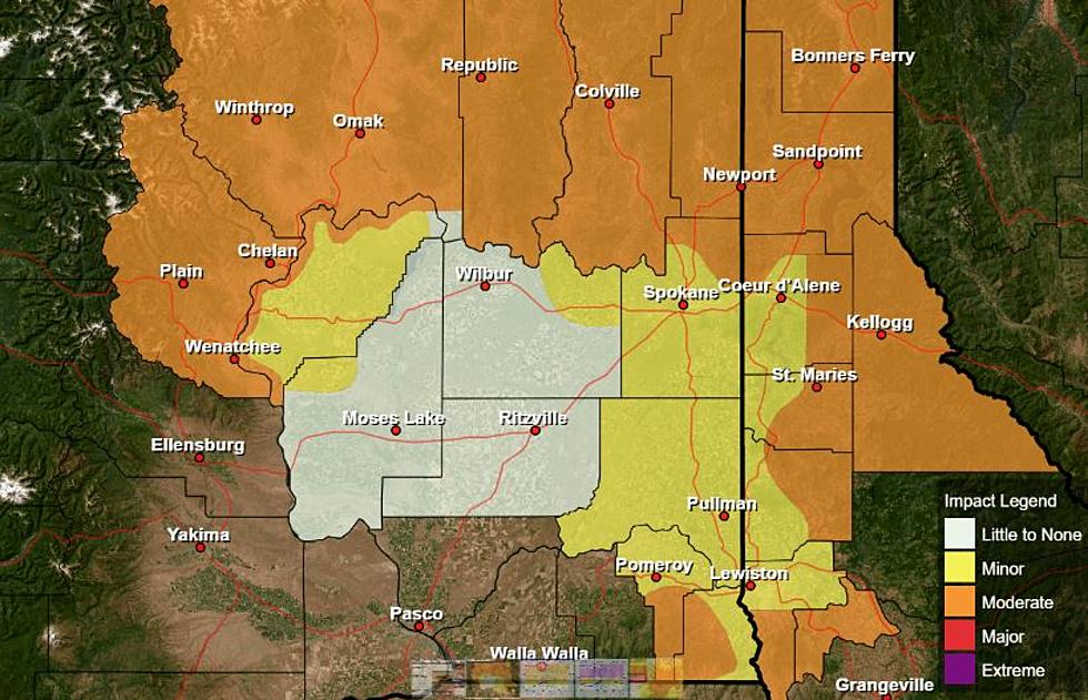
It’s been a very mild couple of days across the PNW. Marilyn Lomann, meteorologist with the National Weather Service said many areas reported record or near record daytime highs on Monday, and that looks to be repeated Wednesday. And while the mild temperatures are great news for those out working in the fields, she notes it has unfortunately has done a number to the snowpack across the area.
“Mid-month we were kind of looking like ‘oh this is nice, our snowpack numbers are near normal’ but now, the Blues and the and especially the Oregon Cascades on up into the central Washington Cascades with all of that warm temperatures and then the rain on top of the snow are well below normal numbers. There’s virtually, expect at the highest elevations not a lot of snow showing.”
Lohmann noted the northern Washington Cascades have not seen the drastic melt off and still enjoy a nice blanket of snow, but it’s nowhere near what was reported just a few weeks ago.
Lohmann said it looks like these warm temps will move out of the area as we approach the end of the week with weak systems rolling in over the weekend.
“[We’ll see] scattered precipitation, right now it doesn’t look like we’ll see anything too heavy, but hopefully we’ll start to see some snow back in the mountains. But then the overall 8-14 day forecast out through the mid portion of the month is showing maybe a fluctuation back to a little bit warmer temperatures, but still above normal precipitation.”
Is Lohmann concerned about where our snowpack is for this time of year? Listen to our podcast to find out.
If you have a story idea for the PNW Ag Network, call (509) 547-1618, or e-mail gvaagen@cherrycreekmedia.com
More From PNW Ag Network